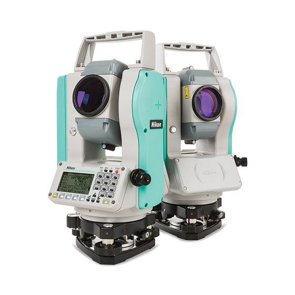
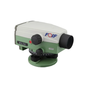
Nikon K series total station

Designed for professional surveying and construction applications, this advanced total station delivers precise angle and distance measurements, onboard data collection, Bluetooth connectivity, and long battery life. Lightweight, durable, and easy to use, it provides reliable performance for topographic surveys, construction layout, engineering projects, and geospatial data collection.

About the Nikon K series total station.

The Nikon K Total Station with Single Display is a powerful yet light Mechanical Total Station that makes Surveying and Construction measurement jobs accurate, quick, and convenient. The Nikon K Total Station uses a single prism (sold separately) with a distance measurement accuracy of up to ±(2 + 2 ppm x D) mm with a range of 13,123 feet. Its Optical Plummet has a 2″ or 5” field of view with 3x magnification. Furthermore, it has a dual-axis compensation with a liquid-electric detection at ±3 range. Convenient to use. The Nikon K Total Station is already integrated with Nikon onboard software, so you can be assured of an easy, straightforward workflow. The K 2″ Series Total Station has a dual monochrome backlit display, while the 5″ Series Total Station has a single display. Both can store up to 50,000 records. Just as important, you can rely on Nikon’s customer support and services anytime it is needed. Portable yet tough. The Nikon K Total Station n will work with you as long you need it to. It weighs only 11 pounds, and is built with a comfortable handle designed for portability. It has an IP55 rating that assures it is protected against dust, rain, and water jets often encountered in worksites. Extend your hours for as long as you need. The Nikon K Total Station has a Li-on battery pack that can work up to 22 hours with continuous angle measurement. It comes with a USB-C charger, so you can charge your unit even in remote work sites. Send data easily. After all your hard work, you can transfer your data from the Total Station to a computer or mobile phone using Bluetooth connectivity. For iOS and Android phone users, the Total Station File Transfer app can be installed on a phone to send coordinate data to the Nikon K. The phone can then also receive observation and coordinate data from the Total Station. These connectivity features allow data to be sent to the office before the staff get back, ensuring prompt processing.

Specifications

Feature / Specification

Feature / Specification Details
Distance Measurement Accuracy ±(2 + 2 ppm × D) mm
Prism Range Up to 13,123 ft (4,000 m)
Display Single Display (5")
Data Storage Up to 50,000 Records
Optical Plummet 3x Magnification
Field of View 2" or 5"
Compensator Dual-Axis
Compensation Range ±3′
Battery Type Li-Ion Rechargeable
Battery Life Up to 22 Hours
Charging Port USB-C
Connectivity Bluetooth
Protection Rating IP55
Weight Approximately 11 lbs (5 kg)
Data Transfer PC, Android & iOS Compatible
Applications Surveying, Construction, Engineering, Mapping

Backed by GeoSurv Africa

Calibration, repair and accuracy testing for most professional brands.

We match the kit to your accuracy needs and budget, no upselling.

Phone, email or WhatsApp a person who actually knows the gear.

Cover project peaks or service downtime with short-term hire.

What is the Nikon K Total Station used for?

The Nikon K Total Station is used for land surveying, construction layout, topographic mapping, engineering surveys, boundary measurements, and infrastructure development projects.

How accurate is the Nikon K Total Station?

The instrument provides distance measurement accuracy of up to ±(2 + 2 ppm × D) mm when used with a prism.

How many records can the Nikon K Total Station store?

The onboard memory can store up to 50,000 measurement records for efficient field data collection.

Can the Nikon K Total Station connect to smartphones?

Yes. The instrument supports Android and iOS devices through Nikon's Total Station File Transfer application.

Trusted by Professionals

The quality of the equipment and level of service exceeded our expectations. GeoSurv Africa has become our preferred surveying solutions provider.

Sipho DlaminiSenior Surveyor

GeoSurv Africa has been instrumental in helping us deliver projects accurately and on schedule. Their equipment is reliable, and their support team is always ready to assist.

Pieter Botha,Project Manager

GeoSurv Africa's commitment to quality and customer satisfaction sets them apart. Their knowledgeable team always provides practical solutions tailored to our needs.

Andrew SmithLand Surveying Professional

The training and technical support we received were invaluable. The team ensured we were confident using the equipment and achieving accurate measurements from day one.

James PetersonEngineering Survey Specialist

Reliable products, expert advice, and excellent service. GeoSurv Africa continues to play an important role in helping us deliver successful projects on time and within budget.

Thabo MokoenaDavid Nkosi, Land Surveyor

GeoSurv Africa consistently provides reliable surveying equipment and exceptional support. Their team helped us select the right solution for our project, and the results exceeded our expectations.

Richard BothaInfrastructure Project Coordinator

They helped us choose the right equipment based on our actual project needs. Honest advice, quality products, and excellent after-sales support.

Ryan JacobsCivil Contractor, Durban, Durban
Products

Browse by Industry & Category